Demographic Characteristics
Population Size and Growth Rates
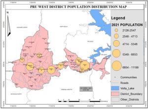
The District has an estimated population of 78,005 (GSS, 2021) with a relatively high growth rate of 3.0%, which is higher than the regional and national growth rates of 2.7% and 2.1% respectively. Out of this population figure, males account for 51% (39,978) while females constitute 49% (38,027). The district’s population represents about 5.77% of the regional estimated population of 1,203,400 (GSS, 2021).
Population Density
In 2021, the population density stood at 40.1 persons per km². With a static land size of 2,195 km² and a continuously growing population, there is increasing pressure on the district’s fragile environment and natural resources. If pragmatic measures are not taken, this may gradually result in environmental degradation.
Household Composition
The composition and structure of households reflect the general social structure of the society. According to the 2021 PHC, the average household size in the district is 5.0 compared to the regional average of 4.17.
Religious Composition
Christianity forms about 54.18% of the population, while Islam represents 18.93%. African Traditional Religions constitute 13.28%, while 12% of the population report no religious affiliation. The remaining 1.61% belong to other minor religious groups.
Age and Sex Composition
The district has a largely youthful population. The age group 0–14 years constitutes 42.9%, the 15–64 years group forms 51.3%, while those aged 65 years and above represent 4.3% (GSS, 2021). Males account for 51% of the population while females make up 49%.
Dependency Ratio
The district has a relatively high dependency ratio of 77.0%. The male dependency ratio is 96.27 while that of females is 87.84. The urban dependency ratio is 77.37 compared to the rural dependency ratio of 101.82.
Rural–Urban Split
The district is predominantly rural, with 55.84% of the population residing in rural areas. The remaining 44.16% live in urban centers such as Prang, Zabrama, Abease, Dama Nkwanta, and Komfourkrom.
Spatial Distribution of Population
The district has 88 localities, with most settlements located along the main road from Prang to Kintampo through Abease. Prang, Dama Nkwanta, Abease, Komfourkrom, and Zabrama are the main urban localities, accounting for 44.16% of the district population.
Key Development Issues
- High population growth rate
- High immigration rate
Physical Characteristics
Location and Size
The Pru West District was established under Legislative Instrument (L.I.2335) of 2017 and inaugurated on 15th March, 2018. The district lies between Longitudes 0030” W and 1026” W and Latitudes 7055” N and 8055” N. It shares boundaries with six (6) other administrative districts, namely Pru East to the north, Sene West to the east, Nkoranza and Atebubu-Amantin to the south, and Kintampo North and Kintampo South to the west, all in the Bono East Region. Prang is the administrative capital of the district and is about 280 km from Techiman (via Nkoranza), the regional capital, and 453 km north of Accra, the national capital. The Pru West District covers an area of 2,195 km².
Relief and Drainage
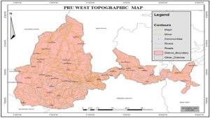
The topography of the district is generally plain, there are few areas with rolling and undulating land surface with elevation between 60 – 300 meters above sea level. The district is unfortunately not associated with any significant highlands or hills except in the Benim (Buom) and Bronikrrom areas where a few matured hills and caves can be found. The Pru River, a right tributary to the Volta Lake flows across the southern parts of the district. The Volta Lake, the Pru River and its tributaries drains the District.
Climate
The Pru West District is located within the transitional zone, thus, experiences the tropical continental or interior Savannah type of climate, which is a modified form of the wet semi-equatorial type of climate. The total annual rainfall ranges between 800mm and 1,400mm and occurs in two seasons. The first rainy season begins June whilst the second rainy season begins in August. It records temperature ranges from a height of 30°C in March to as low as 24°C in August. Mean annual temperature ranges between 26.5°C and 27.2°C.
Key Development Issues
- Rainfall variability
- Drought
Vegetation
The District falls within the interior wooded savanna or tree savannah. However, due to the transitional nature, the area does not exhibit typical savannah conditions. The savannah used to be heavily wooded, though most of the trees are not as tall and gigantic as those in the moist deciduous forest but due to climate change impacts and anthropogenic activities, the prevailing natural condition is altered. Common trees species found outside the few dotted “fringe forest” include dawadawa, acacia, sheanut and mahogany which have adapted to this environment. Grass grows in tussocks and can reach a height of 10 feet or more.
Key Development Issues
- Illegal logging
- Charcoal burning
- Urbanization
- Activities of herdsmen
Habitat Loss and Degradation in the Pru West District
Habitat loss and degradation in the Pru west district is driven by a combination of agricultural expansion, bush fires, fuel wood extraction and localized land clearing for residential facilities, a pattern so consistent.
These losses are not evenly distributed: Forest fragmentation is concentrated near transport corridors, expanding farm frontiers and around residential areas. The district is dominated by small holder agriculture and expanding road networks, activities well known to convert habitat to cropland or degraded secondary regrowth.
Recurrent bushfires in the region also convert wooded and savanna habitats to degraded lands that are slower to recover reducing structural complexity and biodiversity values.
Beyond tree cover, impacts include loss of riparian vegetation along the pru and other tributaries which increased erosion and sedimental load, emergence of invasive species and decline in habitat for forest dependents birds and small mammals.
Land-use change: patterns, drivers and implications for planning
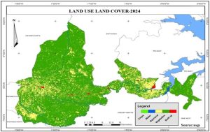
Land-use change in Pru West predominantly follows the agrarian expansion pathway: conversion of woodland/savanna/secondary forest to croplands (maize, cassava, yam, rice in lowlands) and to peri-urban uses. Remote sensing (Global Forest Watch and related forest change analyses) indicates a modest but persistent net decline in tree cover between 2000 and 2020 with episodic losses continuing afterwards — a signal of gradual conversion and fragmentation rather than wholesale deforestation.
At district scale, the primary proximate drivers reported in district planning and programme documents are population pressures in growth corridors (Prang and adjoining towns), shifting cultivation and fallow shortening, charcoal and fuelwood harvesting, and expansion of small-scale sand winning activities.
Land-use change is also driven by infrastructural investments (feeder roads and housing), which create both direct land take and indirect incentives for settlement and land subdivision. Climate-related stressors, more erratic rainfall and occasional severe dry seasons interact with land-use change. They push farmers to open new lands and to intensify use of riparian and marginal lands for cultivation, increasing erosion, and reducing soil carbon.
Soil
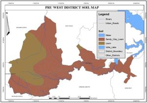
Soils in the district belong to a group called “groundwater lateritic soils” which cover nearly three-fifths of the interior wooded savanna zone of Ghana. These soils are formed mainly over Voltaian shales and granites. Most of the soils are fine-textured, ranging from fine sandy loams to clayey loams, and are mostly poorly drained. Crops that can potentially be supported by these soils include rice, vegetables, yams, cassava, maize, groundnuts, soya beans, cowpeas, tobacco and sorghum.
Key Development Issues
- Soil erosion
- Loss of fertility
- Bad horticultural practices
Figure 4: Soil Distribution
Geology and Minerals
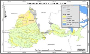
The district is underlain by the voltaian formation which covers about two-fifths of the surface area of Ghana. The rocks belonging to this formation are rich in sandstone, shales, mudstone and limestone which can be harvested for constructional purposes in the district. There are also few deposits of clay which when given the needed attention can boost the pottery industry to generate revenue for the local inhabitants. Parts of the district is exposed to high erosion and weathering of rocks.
Key Development Issues
- High erosion rate
- Clay deposits
- High level of weathering
2.3.3 Oil and Gas
Pru West is one of the 32 identified districts for the potential onshore oil and gas exploration and development along the voltaian basin by SEA carried out by the Environmental Protection Agency. GNPC and relevant stakeholders have started gathering seismic data and information along the basin for further analysis. This has the potential of opening up the district to both local and foreign migrants.
Key Development Issues
- High immigration
- Imminent increase in crime
2.3.4 Water Resources
Pru West District is endowed with significant water resources, both surface and underground. However, the spatial and temporal availability of water remains a major determinant of livelihoods, agriculture, health, and socio-economic development in the district. Many surface water sources are prone to seasonal drying, pollution from agricultural runoff, and degradation due to deforestation and encroachment. Groundwater is the most reliable source of potable water in the district. Boreholes fitted with hand pumps and mechanized systems provide water to many communities.
Key Development Issues
- Seasonal variability and climate change impacts
- Low water table
- Pollution from agricultural and domestic sources
Plants and Animals Life
The vegetation in the district is predominantly savannah woodland, interspersed with patches of gallery forests along riverbanks and wetlands. Native plant species include shea (Vitellaria paradoxa), dawadawa (Parkia biglobosa), baobab (Adansonia digitata), acacia, and various grasses and shrubs. Wildlife in the district includes small to medium-sized mammals, such as grasscutters, antelopes, bush pigs, and monkeys, as well as reptiles like snakes and monitor lizards. The river systems and wetlands support aquatic life such as tilapia and catfish, along with amphibians and waterfowl.
Key Development Issues
- Land conversion for farming and settlement expansion
- Bushfires, especially during the dry season
- Illegal logging and charcoal burning
- Unregulated hunting and fishing practices
- Invasive plant species affecting native flora
2.4.3: District Economy
This section evaluates the state of the district economy focusing on activity status, occupational structure, income levels, revenue, and expenditure, markets, financial institutions among others.
The district is noted for production and supplying in large quantities of yam for the booming Atebubu, Ejura, Kintampo, Techiman, Accra and Kumasi yam markets, cattle and other food crops are also produced in the district. The service industry over the year is witnessing expansion especially in the areas of trading, telecommunication and retail, shops and bars.
Major Economic Activities
The district has a youth population which is labour active, 71.7 percent are economically active and 28.3 percent economically not active. Out of the economically active population, the employed population constitutes 97.6 percent while the unemployed constitute 2.4 percent in the district (GSS, 2021).